


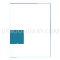
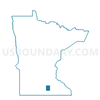
Freedom Twp. Voting District, Waseca County, Minnesota
About
Outline

Summary
| Unique Area Identifier | 604744 |
| Name | Freedom Twp. Voting District |
| County | Waseca County |
| State | Minnesota |
| Area (square miles) | 36.12 |
| Land Area (square miles) | 35.82 |
| Water Area (square miles) | 0.31 |
| % of Land Area | 99.15 |
| % of Water Area | 0.85 |
| Latitude of the Internal Point | 43.98198180 |
| Longtitude of the Internal Point | -93.71113550 |
Maps

Graphs
Select a template below for downloading or customizing gragh for Freedom Twp. Voting District, Waseca County, Minnesota


Neighbors
Neighoring Voting District (by Name) Neighboring Voting District on the Map
- Alton Twp. Voting District, Waseca County, MN
- Byron Twp. Voting District, Waseca County, MN
- Danville Twp. Voting District, Blue Earth County, MN
- McPherson Twp. Voting District, Blue Earth County, MN
- Medo Twp. Voting District, Blue Earth County, MN
- St. Mary Twp. Voting District, Waseca County, MN
- Vivian Twp. Voting District, Waseca County, MN
- Waldorf Voting District, Waseca County, MN
- Wilton Twp. Voting District, Waseca County, MN
Top 10 Neighboring County Subdivision (by Population) Neighboring County Subdivision on the Map
- McPherson township, Blue Earth County, MN (466)
- St. Mary township, Waseca County, MN (460)
- Alton township, Waseca County, MN (434)
- Wilton township, Waseca County, MN (365)
- Medo township, Blue Earth County, MN (364)
- Freedom township, Waseca County, MN (326)
- Vivian township, Waseca County, MN (259)
- Danville township, Blue Earth County, MN (240)
- Byron township, Waseca County, MN (230)
- Waldorf city, Waseca County, MN (229)
Top 10 Neighboring Place (by Population) Neighboring Place on the Map
Top 10 Neighboring Unified School District (by Population) Neighboring Unified School District on the Map
- Waseca Public School District, MN (12,479)
- Maple River School District, MN (6,069)
- Janesville-Waldorf-Pemberton Public School District, MN (4,857)
Top 10 Neighboring State Legislative District Lower Chamber (by Population) Neighboring State Legislative District Lower Chamber on the Map
Top 10 Neighboring State Legislative District Upper Chamber (by Population) Neighboring State Legislative District Upper Chamber on the Map
Top 10 Neighboring 111th Congressional District (by Population) Neighboring 111th Congressional District on the Map
Top 10 Neighboring Census Tract (by Population) Neighboring Census Tract on the Map
- Census Tract 1713, Blue Earth County, MN (3,822)
- Census Tract 1714, Blue Earth County, MN (3,601)
- Census Tract 7903, Waseca County, MN (3,137)
- Census Tract 7902, Waseca County, MN (2,666)
Top 10 Neighboring 5-Digit ZIP Code Tabulation Area (by Population) Neighboring 5-Digit ZIP Code Tabulation Area on the Map
- 56093, MN (12,831)
- 56048, MN (3,898)
- 56065, MN (2,844)
- 56072, MN (2,389)
- 56068, MN (1,087)
- 56078, MN (476)
- 56091, MN (367)